
By ALLISON MOLLENKAMP
Capital News Service
ANNAPOLIS, Md. — The General Assembly’s redistricting group released four draft congressional maps Tuesday, but critics say the maps show signs of continued gerrymandering.
The Legislative Redistricting Advisory Commission, established earlier this year by the Legislature’s Democratic leadership, released the maps days after the state’s other redistricting commission delivered their maps to the governor.
The Maryland Citizens Redistricting commission was established by Gov. Larry Hogan, R, and presented congressional and state legislative maps to him last week.
The citizens commission was made up of three registered Democrats, three registered Republicans, and three unaffiliated voters.
The legislative commission included four Democratic members of the Legislature, two Republican members of the Legislature, and Chair Karl Aro, who formerly led the Department of Legislative Services.
In a statement Wednesday, Hogan shared his displeasure with the draft maps from the legislative commission, while touting the map delivered to him by the citizen’s commission as fair and not drawn by “partisan politicians.”
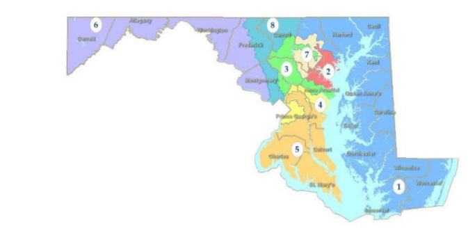
The Legislative Redistricting Advisory Commission released draft congressional maps Tuesday. Draft Map 2 is pictured here. Legislative Redistricting Advisory Commission. The maps on the General Assembly website are interactive and seachable.
Tuesday evening, Senate President Bill Ferguson and House Speaker Adrienne Jones released a joint statement.
“We are pleased that LRAC is releasing four draft Congressional maps now, providing the public with several weeks for input and reaction,” Ferguson and Jones wrote.
Maps from both commissions are expected to be considered in a special session of the General Assembly starting Dec. 6.
In a letter released alongside the map, Aro wrote that the maps “to the extent practicable, keep Marylanders in their existing districts. Portions of these districts have remained intact for at least 30 years and reflect a commitment to following the Voting Rights Act, protecting existing communities of interest, and utilizing existing natural and political boundaries.”
Aro went on to seemingly acknowledge criticism of the congressional lines drawn in 2011, which went all the way to the U.S. Supreme Court, which ruled that partisan gerrymandering is a political question “beyond the reach of the federal courts.”
“It is our sincere intention to dramatically improve upon our current map,” Aro wrote.
Those two intentions might be in conflict, according to Beth Hufnagel, who heads the redistricting team for the League of Women Voters of Maryland.
“I’m struggling a little bit with those two goals,” Hufnagel said.
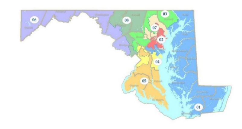
The Legislative Redistricting Advisory Commission released draft congressional maps Tuesday. Draft Map 3 is pictured here. Legislative Redistricting Advisory Commission.
Critics say improving upon a gerrymandered map doesn’t mean the drafts are perfect.
“The map beforehand was nationally recognized as one of the most gerrymandered maps in the country, so almost anything that isn’t as bad is better.”
That’s according to Todd Eberly, an associate professor of political science and public policy at St. Mary’s College of Maryland.
“This is what happens when you already have a pretty serious gerrymander, but you know that you’re under greater scrutiny because more people are paying attention,” Eberly said.
Eberly told Capital News Service that he believes the legislative commission wanted to make a map that looked “better” or less gerrymandered, while prioritizing protecting Democratic incumbents in Congress and maintaining partisan advantage.
The legislative commission’s maps vary in their treatment of different areas of the state, with noticeable potential changes to District 1, where Rep. Andy Harris, D-Cockeysville, is the only Republican member of Maryland’s congressional delegation.
Eberly said two of the draft maps could change the partisan balance of the Eastern Shore district.
“I think both of the maps that take the first district and bring it across the bridge and into Anne Arundel County make the first district a much more competitive district, if not a district that actually favors a Democrat slightly,” Eberly said.
Eberly also pointed to Districts 3, 4, and 7, which he said “continue to be pretty serious gerrymanders.”
District 2, according to Eberly, has been “cleaned up a little bit,” in some of the draft maps.
Cleaning across the map may not have gone far enough, according to Helen Brewer, a legal analyst with the non-partisan Princeton Gerrymandering Project.
“The shapes of the districts are definitely less compact,” than those in the maps released by the citizens commission, Brewer said.
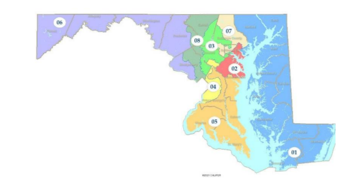
LRAC Map 4: The Legislative Redistricting Advisory Commission released draft congressional maps Tuesday. Draft Map 4 is pictured here. Legislative Redistricting Advisory Commission.
Of course, the shape of congressional districts isn’t the only way to evaluate whether gerrymandering has occurred.
Brewer said “people in Maryland really are of course the experts on their own state,” and can evaluate how the proposed district lines interact with different cities and counties.
Geographic features like rivers and mountains can lead to districts that look odd on paper but keep communities of interest together, Brewer added.
The legislative commission worked to give different communities an opportunity to advocate for themselves in the map drawing process by holding meetings around the state.
Hufnagel, with the League of Women voters, said while she can’t point to specific examples from the wide range of speakers at the public meetings, “they have incorporated some testimony into their map choices.”
The presence of choices is both a positive and a negative for Hufnagel; she thinks having more than one option for now will be good, while the commission can take public input.
“We do hope… that they can narrow it down to one at the beginning of December,” Hufnagel said.
The differences between the citizens commission and legislative commission maps could come down to their makeup.
Brewer said the Princeton Gerrymandering Project generally prefers to see maps drawn by commissions independent of state legislatures.
“Any time that legislators are involved in drawing maps … across both sides of the aisle, they are going to be incentivized to keep themselves or their party in power,” Brewer said.
The gerrymandering project scores maps based on partisan fairness, competitiveness, and geographic features.
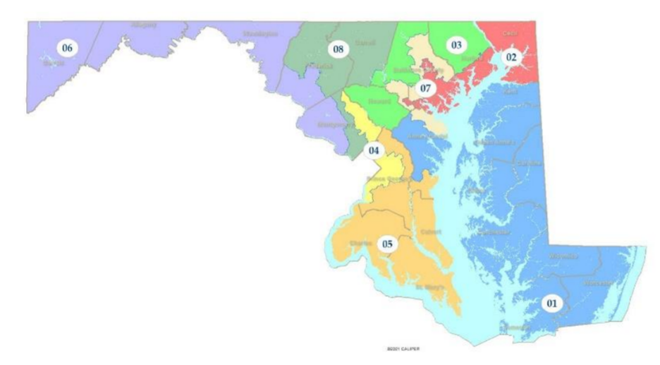
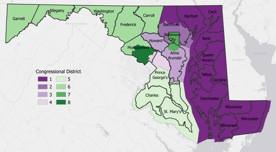
The Maryland Citizens Redistricting Commission submitted this draft congressional map to Gov. Larry Hogan, R, on Friday. Maryland Citizens Redistricting Commission.
They have not yet released grades for the legislative commission’s maps.
Brewer said the citizens commission maps scored well on partisan fairness, which she said is consistent with maps from independent commissions.
“Those maps are not guaranteed to be the ones that will be enacted into law,” Brewer said.
Democrats hold a supermajority in the Legislature, where the legislative commission’s maps may be more likely to pass.
More input on the maps is likely on the way.
Common Cause Maryland, a government watchdog group, said in a statement Wednesday they are working with partner organizations to evaluate the draft maps based on their “impact on the voting power of historically marginalized Maryland communities, as well as partisan fairness, and traditional redistricting criteria.”
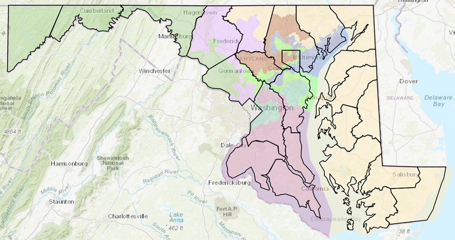
Maryland’s existing congressional map went all the way to the U.S. Supreme Court. Districts are color-coded and county lines are shown in black. Maryland Department of Planning.
Federal law directs how states are able to consider race when drawing congressional maps.
Common Cause added they hope the Legislature will release updated reopening guidelines for the upcoming special session.
“We urge legislators to continue to make the redistricting process open and transparent by ensuring the session is accessible.”
The special session will include consideration of congressional maps.
State legislative and Senate districts are expected to be considered during the regular session in 2022.
The citizens commission presented draft state-level maps to the governor; the legislative commission has only released congressional drafts.
The legislative commission plans to hold a statewide redistricting hearing virtually on Monday at 6 p.m.
That commission is also scheduled to meet the evening of Nov. 18, in North East, Maryland.


Outstanding unanswered questions:
1) Why did the MGA forego a Hispanic plurality seat in every map? Was equity’s political price really appeasing Steny Hoyer? And was that worth it for not having 5 majority-minority seats, including a Hispanic seat?
2) Given the electoral prospects for next year, why didn’t their 7-1 maps load up more Republicans into the 1st District as an option? Surely such legislators uploaded the block equivalency files into District Builder to see the partisan spitouts.
3) Why didn’t they include the non-partisan citizen’s redistricting map as a fifth option?
Please make a note that the redistricting map offered by the Citizen’s Committee is at the bottom and the map above it shows the current boundaries implemented a decade ago.
The four maps offered by the Legislative Redistricting Advisory Commission are absolutely unacceptable and should be thrown out. The map offered by the Citizen’s Committee should be the one chosen. It’s not perfect but is a map drawn with integrity and fairness. Should the legislature go with one of the four egregious choices, I urge the Governor to veto that choice and if necessary, bring forth a lawsuit! It worked 20 years ago with the State Legislative map back then; it should work again!
Guess the legislature really hated the Hispanic population in the Washington suburbs since they are not a plurality in any offered maps despite a sufficiently succinct population.