The following column ran in the October issue of The Business Monthly, a newspaper serving Howard and western Anne Arundel counties.
By Len Lazarick
The cries of outrage and opposition by Anne Arundel officials of both parties were predictable when the Maryland Transportation Authority announced in August that it had narrowed it choices for a third Chesapeake Bay bridge.
All three options are in Anne Arundel County, already suffering from bridge traffic.
The report is part of a three-year, $5 million process required by federal law to construct major projects like this.
“Any of the three options will be severely disruptive to existing communities and sensitive environmental areas,” said County Executive Steuart Pittman. Environmental groups agreed, most preferring the “no-build” option that is a standard part of any major highway study. The new study explained:
“Under 2040 No-Build conditions, hourly travel demand is predicted to exceed the capacity of the Bay Bridge in at least one direction for five hours on an average weekday (as compared to three hours in 2017) and 12 hours on a summer weekend day (as compared to 10 hours in 2017).”
When there’s a crash on the bridges and their approaches, as happens over 100 times every year, delays are worse. Due to congestion, there are more accidents per vehicle miles traveled on and around the bridges than on Maryland’s other “urban freeway expressways,” says the study.
14 Bay crossing options pared to 3
The MDTA, which is entirely funded by tolls, began its federally required study to relieve Bay bridge traffic in 2017. It first examined 14 options for a Bay crossing. Most of them were costly and made little sense. The study pared it down to three.
One option put a new span from Pasadena to Rock Hall in Kent County, one of the most rural and untouched areas of the Eastern Shore. To the south, the third option would put a bridge from the Mayo peninsula in Anne Arundel to Easton. Mayo residents have long opposed wider roads and more intense development.
Gov. Larry Hogan weighed in with remarks that may have compromised the federal evaluation process even more than his toll cuts have undermined the future financing of a project that would cost billions.
“There is only one option I will ever accept: adding a third span to our existing Bay Bridge. While the federal process requires multiple proposals, the data is indisputable— this option would maximize congestion relief and minimize environmental impact.”
This made it sound like MDTA was simply going through the motions, and the outcome of the study was predetermined. That’s what the environmental groups suspected all along.
The shortest route
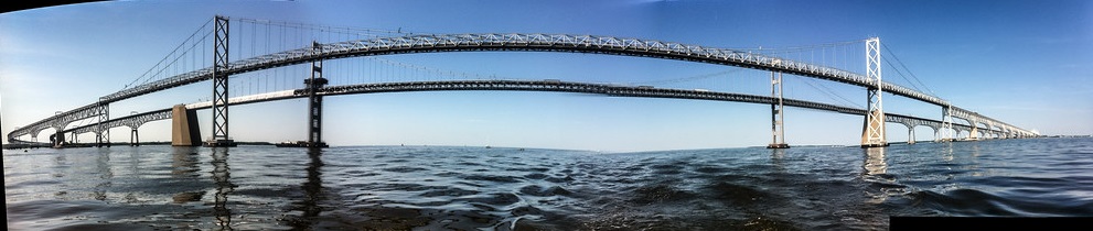
Let’s start with the basics – the reason the existing bay bridges were built there in the first place 67 and 46 years ago.
The crossing to Kent Island is the shortest distance across the middle of the Bay. All the other options, except at the very top of the Bay, have greater stretches of water to cross and are thus much more expensive.
The approaches to the current bridges from the east and west have been built up over the years. The basic infrastructure already exists and any environmental damage has already been done.
Pittman and the environment groups all question the validity of the study’s conclusions.
“The study’s 2040 projections for Bay Bridge traffic are based on an assumption that the Eastern Shore will develop in ways that its communities oppose,” Pittman said. “I suspect that residents will protect their Eastern Shore land from development interests, and that bridge traffic can be better addressed with the forward-looking public transit options that this study dismisses. If we haven’t figured out how to get cars off the road by the time this bridge gets built, we’ll have much bigger problems to confront than traffic. Let’s not build yesterday’s bridge tomorrow.”
An interesting aspect of the study’s data is that two thirds of the current bridge traffic comes from the Maryland counties closest to the bridge. About 41% of bridge traffic comes from Anne Arundel, for instance, and 5% from Howard. Despite efforts to slow down growth by Pittman and others, the Baltimore and Washington Metropolitan Councils – planning agencies independent of MDTA – estimate that these counties will grow by double digits over the next 20 years. Queen Anne’s County is expected to grow by 28%, the highest rate on the Eastern Shore. Many of those new residents will cross the bridge for work, shopping and other services.
Dismissing the alternatives
Pittman and an array of smart growth and environmental groups propose an array of options to reduce traffic that the study examined, but ultimately rejected.
One is variable tolling to reduce peak demand, pushing more vehicles into the evening. But, says the agency, “Variable tolling could shift traffic to nighttime hours, when maintenance activities on the bridge largely occur, negating any benefit.”
How about restoring the ferry routes that once were the only way to get to the shore? A ferry route can only handle about 1,000 vehicles a day, the study says. That doesn’t put much of a dent in 68,000 vehicles that cross the bridges on an average weekday, 118,000 on a summer weekend day. And fares would not likely cover the costs.
How about more transit like rapid buses or even a rail line?
Rapid buses and rail would only take about 1,600 vehicles a day off a summer weekend day, says the MDTA, and a rail line would still require a new bridge.
Even doubling those transit and ferry estimates, they don’t substantially increase the capacity of the bridges.
The communities near Routes 50-301 at both ends of the bridge are already impacted heavily by traffic that makes it difficult for residents and emergency vehicles to get around. In Queen Anne’s County, motorists are being urged to stay off the local roads that provide some slight relief to the weekend traffic jams.
Getting the majority of motorists to abandon their cars, or change where they want to live, work and play seems like wishful thinking.
In any case, relief for travelers and local residents can’t come any time soon. A decision to locate a third bridge won’t be made till at least next year. Finding the billions to actually build it, whether from tolls or federal aid, seems even further off.

One is variable tolling to reduce peak demand, pushing more vehicles into the evening. But, says the agency, “Variable tolling could shift traffic to nighttime hours, when maintenance activities on the bridge largely occur, negating any benefit.”
Variable tolling is a solution to reducing peak traffic (not demand). MdTA already suggests drivers cross the bridge during off-peak times; tolling would prompt them to do so. The statement in quotes is simplistic and condescending. The shifting of traffic and maintaining the bridges would have to be planned and managed properly; that’s not too much to ask.