
This is an updated and revised version of a column that runs in the December issue of The Business Monthly serving Howard and Anne Arundel counties.
Laughable. That was my reaction when I saw the four congressional district maps released by legislative leaders in early November. I laughed.
Let’s call it gerrymander lite. The boundaries were less ridiculous than the maps drawn 10 years ago that had some of the oddest shapes in the country.
But the proposals still bore the imprint of Democrats’ power to draw lines that favor their party. How could they not?
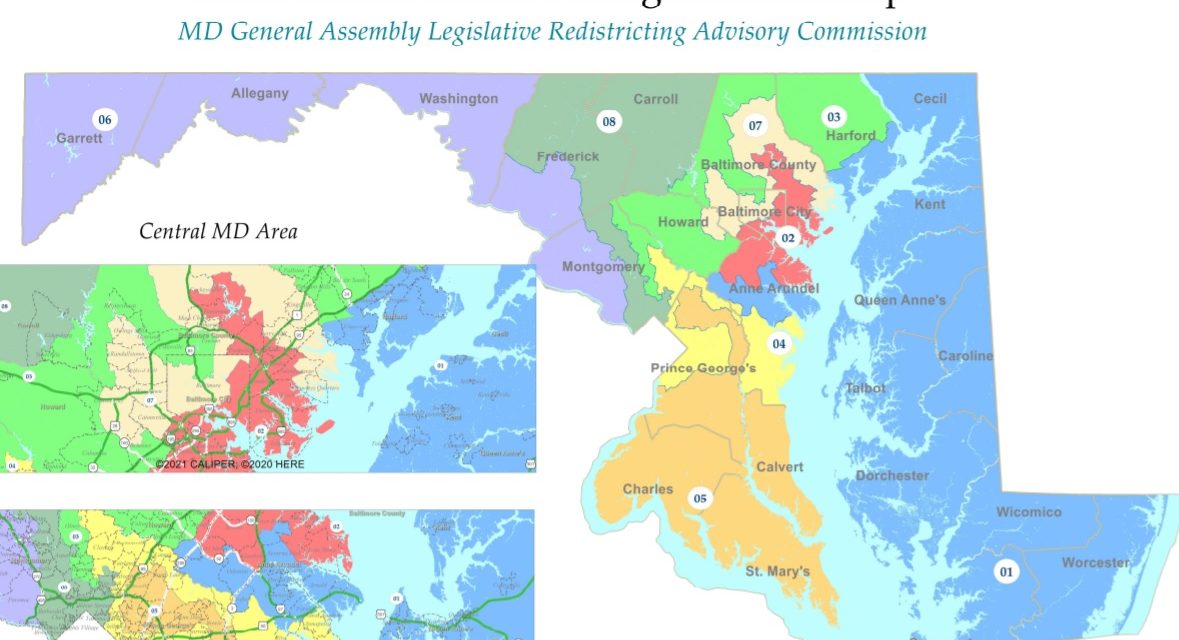
The “message from the Chair” of Maryland General Assembly Legislative Redistricting Advisory Commission — who didn’t even sign his name – said one of the guiding principles was “to the extent practicable, keep Marylanders in their existing districts.” The chair is Karl Aro, former head of the Department of Legislative Services, who led the staff that created the obscenely gerrymandered congressional districts 10 years ago. We gerrymandered you before, and we’re gonna keep you there.
Admittedly, the allegedly nonpartisan staff are simply doing what they are told by Democratic leaders.
“Portions of these districts have remained intact for at least 30 years,” said Aro. True enough. My homes in Owen Brown village of East Columbia have been in the 3rd Congressional District for 40 years now and would remain so. Its boundaries have shifted from its original anchor in a declining Baltimore City population to include Columbia when it was represented by Rep. Barbara Mikulski back in the 1980s. Then it drifted over to include Annapolis — Rep. Ben Cardin at the time was unhappy about that. In the redistricting following the 2010 census, the 3rd swooped down to encompass Silver Spring apparently to accommodate Rep. John Sarbanes. Sarbanes is the sponsor of the “For the People Act,” which among many things that will never pass the U.S. Senate would establish independent commissions in all the states to rid us of the evil gerrymandering.
Egregious examples
“The Chair” said the redrawn districts “reflect a commitment to following the Voting Rights Act, protecting existing communities of interest, and utilizing existing natural and political boundaries.”
The statement did not reflect a commitment to facts or believability.
There were plenty of egregious examples in the draft maps. The most consistent egregious example is the 8th Congressional District, currently represented by Rep. Jamie Raskin, one of the most progressive and respected members of the House.
In all four legislative maps, the district runs 50 miles from the Mason-Dixon line (the Pennsylvania border) to the D.C. line in Silver Spring.
The map legislative leaders hope to pass this week encompasses most of Carroll County – the whitest and one of the most Republican of suburbs and ex-urbs – and northern Frederick County — also rural, white and heavily Republican — down to Silver Spring, one of the most ethnically diverse, liberal and urbanized areas of Maryland.
Ditto the 3rd Congressional District. Its proposed shape is not quite as bizarre as it currently is, but it runs 70 miles from the Susquehanna River and the Pennsylvania border almost to the Capital Beltway in Montgomery County. It includes most of Harford County and northern Baltimore County – both majority Republican – and much of Howard County, including liberal Columbia and a sliver of Montgomery. It also has an arm that stretches into the middle of Baltimore City down to Druid Hill Park.
It’s about as compact as a Humvee.
Little in common
Communities of interest? Natural and political boundaries? What these areas have in common is that they are human beings who live in Maryland.
The only counties that remain intact are the rural counties at the edge of the state’s admittedly craggy shape formed by the ocean, the squiggly shores of the Chesapeake Bay and the meandering Potomac River. The squared off congressional boundaries of the Midwest are impossible here.
What all four maps had in common was that it would be virtually impossible for a Republican to win any but Rep. Andy Harris’s 1st Congressional District based in the Eastern Shore. The Shore only has enough people to make up about half a congressional district, so you have to pick up some folks on the Western Shore.
The map the Democratic leaders settled on (SB1 and HB1) has the 1st District crossing the Bay Bridge, picking up some more Democratic voters. Harris, a right-wing bomb-thrower from his days in the state Senate, has gotten admittedly more wacko in the Freedom Caucus. But bumping him off will be difficult, especially if Heather Mizeur, a gay, progressive former delegate from Takoma Park now living on a Kent County farm, is the nominee. She out-raised Harris and three other Democrats in the race, but Harris still has almost twice as much cash on hand. Money from outside the state is bound to pour in to help each of them.
The Princeton Gerrymandering Project, a nonpartisan group of analysts and researchers, gives all four legislative maps an F for lack of competitiveness and geographic splitting of counties.
More Republicans
Democratic readers must be saying: “This guy just wants us to elect more Republicans.” No, I actually would just like the process to be fair and honest.
About 30% of the legislature is Republican. Even in 2020, Donald Trump got 32% of Maryland’s presidential vote. Republican Larry Hogan won for governor twice, and two-thirds of the counties, mostly rural, are governed by Republicans. Why then should Republicans get just 10% of the Maryland congressional delegation and only 12.5% of its House members?
Because Democrats can, that’s why.
This is the map Gov. Hogan submitted to the legislature. Click the map to go to the interactive version.
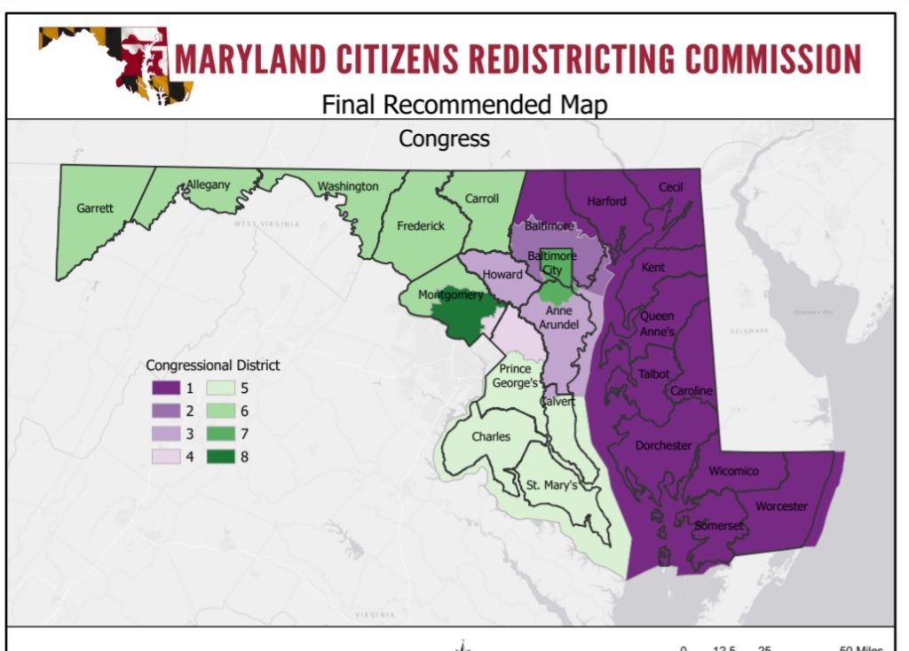
On the other hand, the governor’s Maryland Citizen Redistricting Commission, co-chaired by former Howard Community College President Kate Hetherington, recommended a much more compact congressional map that largely follows county borders working in from the edges of the state.
Its proposed map looks much like the congressional lines of the 1970s. The 6th District would include all of Frederick and Carroll, as it did for decades, meaning only a Republican or a Joe Manchin Democrat could get elected there. Same for the Eastern Shore. And Anne Arundel and Howard counties are put together to make up a potential swing district. The two in recent years have had county executives from both parties.
The Princeton Gerrymandering Project gave this map an A. Hogan submitted the plan to the legislature as SB2, HB2. Like all the previous redistricting commission proposals Hogan has submitted in past years, it will likely die in committee.
Republican-dominated legislatures across the country have continued the same kind of partisan gerrymandering that helps create an imbalance in the U.S. House of Representatives. Maryland Democrats know their own gerrymandering is unfair, but they refuse to engage in “unilateral disarmament” by doing the right thing while the GOP blithely continues to rig electoral outcomes. But two wrongs still don’t make a right.
Sometimes, they do make a law. Hogan can veto the legislative plan, but Democrats would almost certainly have the votes to override him. Someone will take the maps to court. If the courts refused to overturn Maryland’s grotesque congressional districts 10 years ago, why would they reject today’s slightly less offensive redrawing?


Sometimes two wrongs are the closest to right that we can get.
In the absence of the For the People Act, or something like it, I fully stand behind the policy of no unilateral disarmament. The very least that Maryland Democrats should accept would be a “fair redistricting” pact with another, red state that would offset our losses.
And in the time of equity, we see only 3 majority-minority districts. Major population areas like Montgomery County (60-40 maj-min) are split into 3 majority and 1 majority-minority district. It’s appalling that the 2020 Census reflects the minority share of 2000. The fastest growing population of Hispanic is cracked into multiple districts denying a plurality district.
All for partisan politics. No geographic, partisan, or even racial/ethnic equity.
JP,
There are two competing goals here. The first is housing integration, which I see as contributing much better to racial equity in the long run. If we live in a diverse neighborhood, it will be very difficult to craft “majority minority” districts. Requiring
majority minority” districts implies that people only vote for candidates who share their ethnic background. That is clearly not the case, as we can display by looking at the Howard County delegation to the state legislature. Deliberately establishing a district in which a white candidate would not have a chance to win is as bad as doing the opposite.