By Michael Collins
For MarylandReporter.com
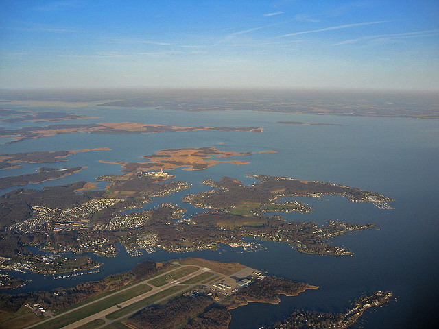
View from Martin State Airport toward the Chesapeake Bay. Photo by Crazy Diamond.
Gov. Larry Hogan last month announced yet another study of a third span across the Chesapeake Bay. The study is expected to cost $5 million and take up to four years. Its goal is to determine the appropriate site for a third span and how to pay for it.
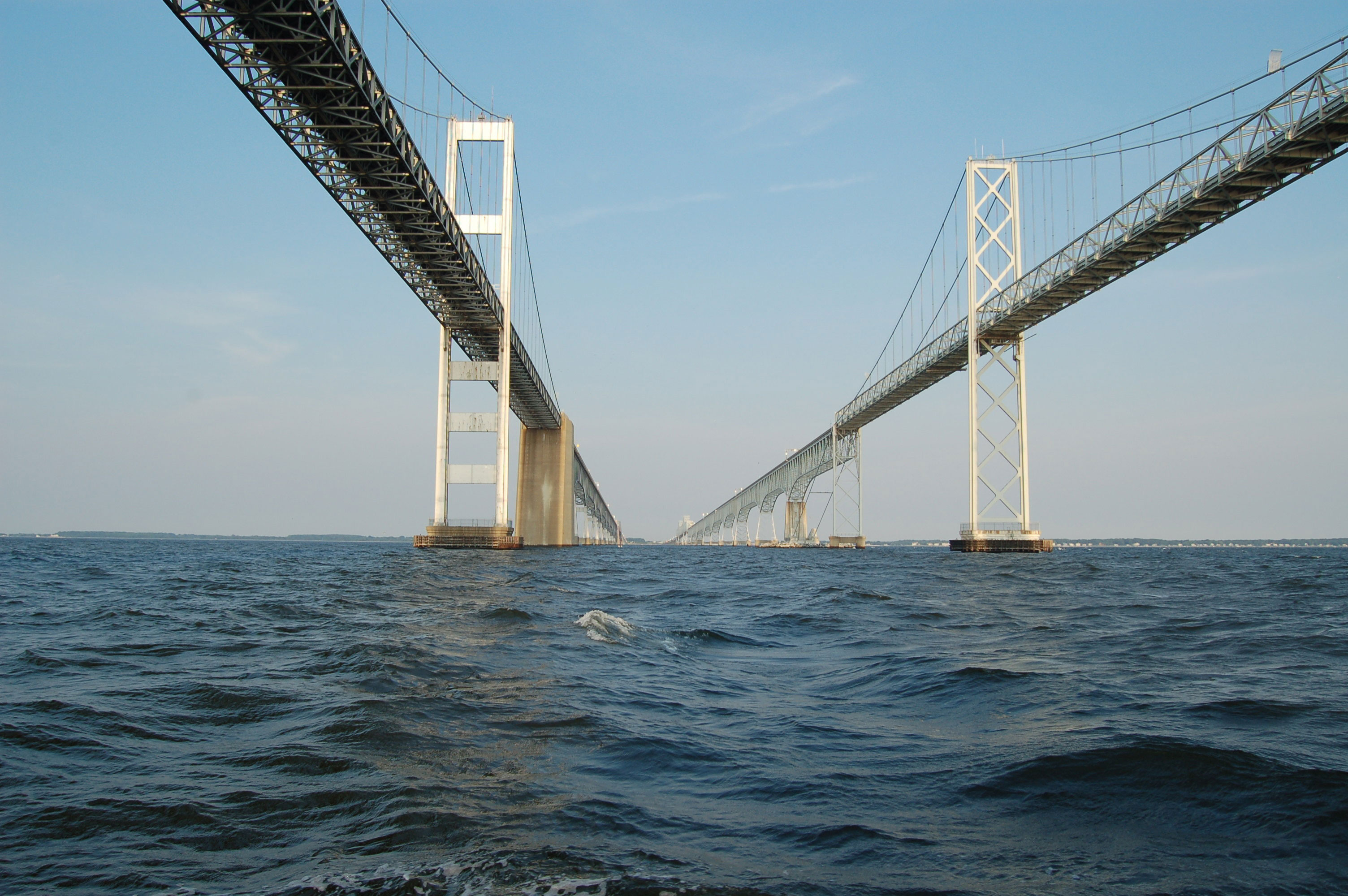
Gov. Hogan’s announcement came with the Governor William Preston Lane Jr. Bridge (aka the Bay Bridge) in the background. The setting suggests that the third lane will be built at the current Sandy Point site. Maryland would be well served, however, by building the next bay crossing from Baltimore County to Kent County.
The 2006 report from the Task Force on Traffic Capacity Across the Chesapeake Bay, like every other before it, has pointed to multiple Bay crossings.
Task force report
The Task Force was a collaborative effort by leading elected officials from around the state and included public input from Anne Arundel, Calvert, Dorchester, Kent, Queen Anne’s counties.
The Task Force divided the Bay into four zones.
Zone 1—Baltimore County to Kent County;
Zone 2—Anne Arundel County to Queen Anne’s County;
Zone 3—Anne Arundel/Calvert Counties to Talbot County (near St. Michaels); and,
Zone 4—Calvert County to Dorchester County.
The existing Bay Bridge is four miles long, with a clearance of 186 feet in height, and a main span of 1,600 feet in length. This is needed to accommodate a channel width of 1,500 feet and the massive ships that travel up the Bay to the Port of Baltimore.
Crossings in Zones 3 & 4 would need to bridge a channel width of more than 10,000 feet, would require a main span of 3,000-4,000 feet, and, depending on location, the total structure could range from 6-12 miles in length. That’s not going to happen.
Zone 1 is called the “historic” northern crossing because it is the original route planned in the early 1900s. It was intended to stretch from Baltimore to Tolchester Beach in Kent County.
Advantages of the northern crossing
A northern crossing need not meet the same dimensions as the Bay Bridge. Shipping arriving in Baltimore from the north is limited by the height of existing crossings and the channel width of the Chesapeake and Delaware (C&D) Canal. For example, the William V. Roth Bridge over the C&D Canal has a clearance of only 100 feet. So the main span of a northern bridge across the Chesapeake Bay most likely would not need to be higher.
In addition, the C&D Canal is only 127 feet wide. The shipping channel width between Baltimore and Kent counties is 600 feet wide, so, the main bridge span could be much shorter than the Bay Bridge.
A smaller main span allows flexibility in design. For example, the Roth Bridge is a cable-stayed bridge. This design has suspension cables from the bridge piers down the center of the bridge that resembles two golden sails and provides passengers unobstructed views.
A bridge with a shorter, lower main span has benefits other than aesthetics. It could offer pedestrian and bicycle lanes, potentially with access to Hart-Miller Island.
Public safety is a consideration too. A bridge with a height of 100 feet would not be as enticing to jumpers as the 186-foot high Bay Bridge. Diversifying our bay crossings is also smart from a homeland security perspective. Having all bay crossings in one location leaves them vulnerable to blockage, either through natural or manmade disaster.
Reducing traffic at current bridges
The 2006 Task Force report showed that a northern crossing would reduce current Bay Bridge crossings by 40,000 cars on a summer weekend and 25,000 cars on an average weekday. While it will require significant cost to improve roads on either side of the Bay for a northern crossing, road improvements to support another span at Sandy Point won’t be cheap.
Route-50 is six lanes wide and has choke points at the Severn River and Kent Narrows bridges. In addition, I-97 and MD-2 are at capacity and are pouring into Rt.-50. Route-50 and Rt.-18 on Kent Island are maxed out too. How much wider can those roads and bridges get?
Environmental issues
Some will say that Kent County is too environmentally sensitive to support a Bay crossing. Others will say that a bridge will change Kent County’s rural character and add traffic to historic Chestertown.
Why should historic Annapolis get any less respect than Chestertown? Isn’t Queen Anne’s County’s environment and rural character precious too?
Nobody wants major transportation infrastructure in his or her backyard. In 1947, then-Gov. Lane created the sales tax to pay for the bridge that bears his name. The sales tax and bridge were so unpopular that it cost Gov. Lane his reelection. But the bridge helped unite Marylanders and bring economic opportunities to residents of the Eastern Shore.
It is clear that Maryland needs a third span across the Chesapeake Bay. A crossing from Baltimore County to Kent County should get serious consideration.
Columnist Michael Collins was heard earlier this week on WBAL radio discussing his MarylandReporter.com column advocating a third Bay bridge between Baltimore and Kent counties. Listen to the four-minute audio by clicking here
Michael Collins can be reached [email protected]


So this author’s logic is that a third bridge is needed. Huh? Where did he derive that conclusion? The last study I read indicated bridge traffic has been stagnant for the last 10 years. The point of the study is the replacement of aging bridges with more capacity – stagnant traffic notwithstanding. If a third span is built, then you are now maintaining 3 bridges and 2 different sets of road infrastructure. In addition, all studies indicate that by 2065, the current bridges will need to be replaced. Another mega cost. All so the mayor of OC can fill those vacant hotel rooms more quickly. Pretty dumb.
There is no sense building a northern span. The majority of the traffic you’re trying to alleviate is beach traffic. Residents north of Annapolis have to travel south anyway…they can use the existing bridge. Residents south of annapolis and DC rrsidents could use a southern crossing. Rt 4 is under utilized between PF and Solomon’s and it’s a good road with plenty of room for expansion. Using Rt 4 as a straight shot out of the city to a southern crossing would benefit everyone. There is no sense using a northern span to dump.more traffic on a road that is already overcrowded.
every single dimension you stated is incorrect. Per the C&D Canal NOAA Chart 12277, the channel width is 450′ and the lowest bridge span is the reedy pt bridge @ 136′. Most of the ships that transit the canal are panamax with a beam of 106′. The MD and DE pilots are good, but safely navigating a 106′ wide ship in a 127′ wide channel would be impossible. Also Most ships require bridge clearances of at least 135′
It seems the author is only concerned with dimensions – channel widths, bay widths and water depths. The reality is that as a Virginian, I don’t want to see direct access from Baltimore to a watershed and historical area. Baltimore represents exactly what the eastern shore does not. If Maryland wants to preserve Its unique heritage and the timeless and beautiful part of the state, then it absolutely cannot allow a northern bridge with the sole purpose of funnelling traffic on to other destinations that serve zero benefit to the future generations who want to preserve what we all value – the Maryland eastern shore.
I don’t really see the logic behind a northern bridge. Where are you going to go once you’ve reached tolchester? There are only 2 options; 1 being that you Create a whole new highway system south connecting to route 50 which is overly congested already, 2
Is that you build a highway connecting to route 1 in Smyrna, DE. Neither one of these seem to be logical due to the extended route and large scale farm land impact/purchase. The most logical is option 4 which connects to Dorchester county. The main congestion once you cross the current bridge happens in queenstown, easton, and Cambridge. By adding a bridge to the south it eliminates a significant road block in these areas. Who cares if the bridge is 12 miles?? It doesn’t have to be 100 feet plus the entire span which will save money and protect the scenery. Dorchester county already has a direct highway in route 16 that empties below Cambridge reducing congestion. Unless the plan is to add limited access highways from Kent island to the Salisbury bypass I cannot see the northern route being successful. Even if a bridge is built in Kent county or Dorchester county, Maryland will need a new 6-8 lane span in queen Anne’s county to replace the old spans by 2065.
The Article is right. The most cost effective Bridge would be a northern crossing connecting Kent and Baltimore counties. It would divert up to about 50% of the traffic, pay for itself in the shortest amount of time, require the least amount of infrastructure build-up compared to other sites, and help unify the State. In addition, the political damage is also minimized given that Kent County has the fewest voters of any country in Maryland.
Dear Mr. Collins,
First, the idea for the ‘historical’ original Tolchester bridge, which dates back to 1909, was conceived at that time to allow western shore vacationers the opportunity to drive, or take a train, to what was then one of a few destination points of the eastern shore that could only be reached by ferry; Tolchester Beach Resort & Amusement Park. When the current bay bridge opened in 1952, the premier destination point for Maryland vacationers, as well as PA and NJ vacationers, became OC. Such was the case that in 1962 the Tolchester Beach Resort & Amusement Park closed, went into bankruptcy and foreclosure.
When the current bay bridge opened it genuinely cancelled the need for a bridge to Tolchester, Kent County, MD, and, frankly, should have been deleted from all future plans. There are two well-established residential communities on the lands that made up the old Resort and Amusement Park; Tolchester Heights and Tolchester Estates, with a combined total of 223 homes.
Second, what your commentary does not take into consideration is the extensive infrastructure that would be required to connect Tolchester, Kent County, MD to DE & MD beaches; the construction of at least two more bridges, to cross the Chester and the Choptank Rivers, never mind the crossings necessary for the numerous stream and creeks throughout the upper Delmarva Peninsula. This is not just about laying down a lot of concrete and asphalt. There are significant and substantial ecological, environmental and heritage impacts involved, which you are not aware of, or if you are, seem to dismiss.
Additionally, Kent County, MD, per our Comprehensive Plan, does not want a bridge to our shore,
does not want to be connected to, nor become a suburb of, either Baltimore County or Baltimore City. Contrary to WBAL Mr. Nehman’s comment that a bridge would be a boon to Kent County, this is absolutely false and would emphatically and categorically culminate in the opposite. This, b-t-w, indicates his, and presumably your, total lack of understanding of the Socio – Economic System that is the Upper Delmarva Peninsula.
Interestingly, during the 2006 study and report, which you cite, Dorchester County implied that it would
welcome a crossing, which, frankly makes a lot more sense, if you truly want to build a bridge, when you look at the total picture, easily connecting that bay crossing to Route 50 just north of the Salisbury by-pass.
The easiest, and most economical plan, however, in my judgment, would be to build a third east bound
span, just one lane, allowing for three lanes of vehicular flow in both directions; eliminate the 11 toll booths, which are a MAJOR travel impediment; adding express by-passes around the traffic light plagued towns Easton and Cambridge.
If you want to improve vehicular traffic flow, Mr. Collins, eliminate the current hindrances, impediments and hurdles.
Mike Waal
Tolchester Heights
Kent County, MD