By CAPITAL NEWS SERVICE STAFF
Capital News Service
ANNAPOLIS, Md. — Flooding in Annapolis Friday night and into the weekend could reach the third-highest level ever recorded, according to the National Weather Service.
Areas along the Chesapeake Bay, including Baltimore City and Annapolis, are expecting coastal flooding, high winds, and heavy rains.
The flood level is expected to peak around midnight Friday, but forecasters predict water levels in Annapolis will remain at moderate flood levels through early Sunday morning.
Some Maryland public school systems were closed on Friday in response to the inclement weather. Closures include schools in Anne Arundel, Calvert, Dorchester, Harford and Baltimore counties.
Connor Belak, meteorologist with the National Weather Service in Sterling, Virginia, told Capital News Service he expects that with winds from the South and East, water levels will continue to increase Friday afternoon and evening.
“There’s a pretty strong southeasterly flow that’s bringing water up the Chesapeake Bay and kind of channeling, funneling it up to points northward,” Belak said.
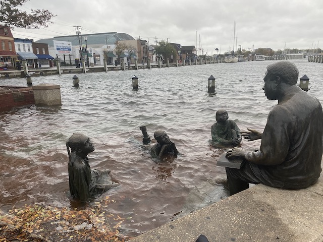
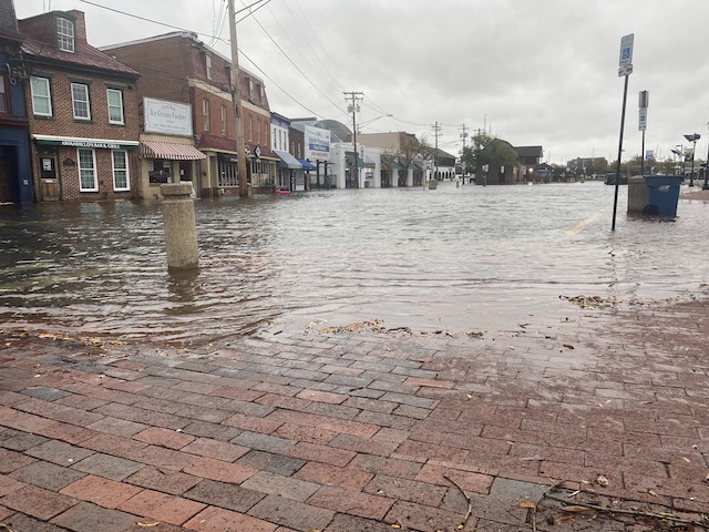
Flood waters will likely cover the boardwalk at City Dock in Annapolis and could affect businesses in the area, including parts of Compromise Street.
In downtown Annapolis, workers and residents said they anticipate major floods Friday and into the evening.
The National Weather Service is predicting tides of around 5 feet — 4 feet above normal.
“What we are hearing is that there should be at least five feet of water coming towards our way,” said Rita Thornton, an employee of the Iron Rooster, an all-day breakfast restaurant.
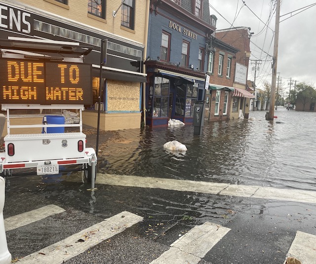
Downtown Annapolis was flooded from Dock Street all the way down the end of the pier on Oct. 29, 2021. (Photo by Alexandra Radovic/Capital News Service)
Thornton said on Friday morning that although the City Dock area was closed down, Iron Rooster, located on Market Space, was remaining open.
“Five feet of water is drastic for any of the businesses down here, especially those that are already flooded out. … (but) we are (open) until further notice.”
The streets were mostly empty as the City Dock area surged with water along Dock Street from Mission BBQ all the way down to the end of the pier.
“At 4.2 feet, the boardwalk at Annapolis City Dock (would be) underwater,” the National Weather Service reported Friday morning. “Floodwaters also are affecting numerous roads in Annapolis and on the Naval Academy Campus, along with structures throughout the neighboring area.”
After a noon high tide on Friday, the weather service warned of the next high tide, at about 1 a.m. Saturday, though waters are not expected to recede significantly between them.
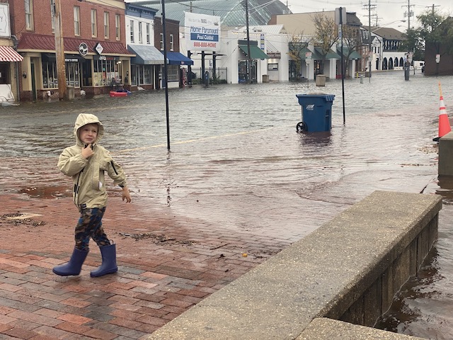
A young boy walked by the water on Dock Street to see flooding by the pier on Oct. 29, 2021. (Photo by Alexandra Radovic/Capital News Service)
Some Annapolis residents didn't take this week's storm predictions seriously Thursday, despite social media pushes and city press releases, because of the deceptively good weather, according to Annapolis Mayor Public Information Officer Mitchelle Stephenson.
"Things are pretty soggy out here," Stephenson said.
Sandbags were offered to residents and business owners with ID all day Thursday, but Stephenson said it took until the afternoon for many people to claim them.
Friday morning, she and Annapolis Mayor Gavin Buckley were out delivering more sandbags, she said, to help block water from lapping at doors.
The city is prepared, Stephenson said, but she urged residents to use common sense when out and about.
The effects of the storm won’t be limited to downtown Annapolis.
“There’s gonna be different impacts at each location,” Belak said.
Climate change has affected Maryland, which has seen an increase in flooding and rainfall in recent years.
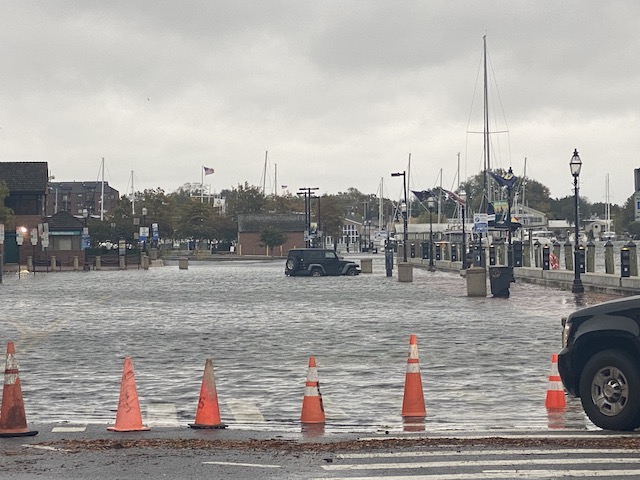
A Jeep was submerged in water due to flooding in Annapolis on Oct. 29, 2021. (Photo by Alexandra Radovic/Capital News Service)
Capital News Service reported earlier this month that, in 2018, Baltimore City had the highest annual precipitation in Maryland over the course of 20 years with 73.84 inches.
“We are putting out sandbags and providing garage parking to our residents in preparation for heavy rainfall...through Saturday evening. Stay safe and don’t drive through standing water,” Baltimore Mayor Brandon Scott posted on Twitter.
Zachary Harris, an employee at Miss Shirley’s Cafe at Baltimore’s flood-prone Inner Harbor, told Capital News Service, “We are full because people don’t want to go back outside…It’s hard to walk against the wind. It’s raining super hard. I’ve seen more than a few umbrellas get broken.”
On Thursday, Baltimore City and state officials announced a $5 million plan to reduce flooding in a northeast Baltimore neighborhood that has experienced flood problems since the 1950s.
Scott said he was a high school student in the neighborhood that is set to receive the funds, and that he remembered having to carefully leave school numerous times to avoid the area because of flooding.
“And now, due to the impacts of climate change, we are seeing heavier rainfall,” Scott said Thursday. “We cannot afford to turn a blind eye to these issues.”
Kasey Thomas, a planner at the Anne Arundel County Office of Emergency Management, said she was hunkered down for a 12-hour in-person shift in Glen Burnie.
She said all those on duty Friday were watching MyCoast Maryland app submissions for resident-reported dangerous environments, connecting worried travelers to road closure information and posting "continuous updates" on the office's Facebook and Twitter.
MyCoast is a mobile application and online tool that allows residents to report nuisance flooding location and extent, as well as damage caused by both rainfall and coastal flooding.
Nuisance tidal flooding and coastal storm damage affected cities and towns across Maryland — including North Beach, Huntingtown, Edgewater, Pasadena, Solomons, Shadyside, Baltimore and Annapolis — according to photos uploaded on Friday to MyCoast. (https://mycoast.org/search-
"We don't want people to panic, but we do want people to take this seriously," Thomas said,
and detour through safer areas.
Dock Street, in downtown Annapolis, was flooded on Oct. 29, 2021. (Photo by Alexandra Radovic/Capital News Service)
Tides in Annapolis are expected to crest around 5 feet, which could be the third-highest level recorded in the city.
Belak, the meteorologist, said the two previous records were during Hurricane Isabel in 2003, when tides were over 7 feet, and in 1933 when tide levels topped 6 feet.
Capital News Service reported earlier this month that over the past 20 years, rainfall, flooding, and sea level have increased across Maryland, according to data collected from the National Oceanic and Atmospheric Administration.
In addition to large floods, rising sea levels have increased the number of “nuisance floods,” or tidal floods that cause minor impacts, by five to 10 times since the 1960s in numerous U.S. coastal cities, according to the 2017 Climate Science Special Report.
The National Weather Service issued a coastal flood warning for much of Central and Eastern Maryland, as well as the Washington metro area and parts of Virginia.
The warning for the shoreline of Anne Arundel County is expected to last until 8 a.m. Saturday.
The northern portion of the Chesapeake Bay is under a gale warning until 8 p.m. Friday and the southern portion, from Drum Point to Smith Point, Virginia, has a storm warning until 6 p.m. Friday.
Forecasters said the storm warning area could see wind gusts up to 50 knots and waves of 3 to 6 feet.
In the gale warning area, the National Weather Service predicts wind gusts up to 45 knots and waves of 2 to 4 feet.
(Video by Bethany Probst/Capital News Service)
City and county officials across the state urged residents to "turn around, don't drown," not to drive into standing water and not to ignore police barricades.
In a press release Thursday, the Maryland Department of Emergency Management encouraged residents to plan in case they need to leave the area.
“Ensure your emergency supply kit is ready to go, let family and friends know about your plans, have a portable radio to listen to weather updates in the event you lose power, make sure all your devices are charged, and that you have an extra supply of batteries.”
The department added that during the pandemic, an emergency kit should also include face masks and hand sanitizer.
The Maryland Insurance Administration suggests gathering copies of insurance information and cataloging belongings in your home or business in case they are damaged.

Recent Comments